Aerial Photography of Minnesota - USGS Sources

The U.S. Geological Survey has provided aerial photography for Minnesota since the late 1940s.
High Resolution Orthoimagery (Twin Cities)
High-resolution, natural-color orthoimagery was flown for the Minneapolis-St. Paul urban area in 2012, 2008, 2006, 2004 and 2002. The 2006 imagery included partnerships with Ramsey and Hennepin counties.
- March/April 2012, Minneapolis - St. Paul: 0.3-meter (approximately 1 foot) resolution. Metadata
- April 2008, Minneapolis - St. Paul: 0.3-meter (approximately 1 foot) resolution. Metadata
- April 2006, Ramsey County: 0.15-meter (approximately 1/2 foot) resolution. Metadata
- April 2006, Twin Cities area: 0.3-meter (approximately 1 foot) resolution. Metadata
- April 2004: 0.3-meter (approximately 1 foot) resolution. Metadata
- October 2002: 0.75 meter (approximately 2 foot)
resolution.
National Aerial Photography Program
NAPP, a nationwide program coordinated by the U.S. Geological Survey, produced photographs of Minnesota for two time periods:
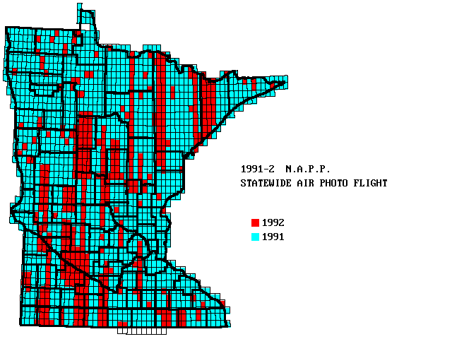
- 1991-92: Most of the state was flown in spring of 1991; the remainder was completed spring 1992. See flight map. Photos are available in both color-infrared and black-and-white; the latter were used to produce statewide digital orthophotos (DOQs). DOQs are computer-readable air photos that have been processed to minimize distortion.
- 1996-98: Over half the state was flown in summer 1996, one-quarter in summer 1997, and the remainder in summer 1998. These photos are black-and-white only with no DOQs.
The original images from both flights are 9" x 9" and cover about 25
square miles at an approximate scale of 1:40,000. The photography was
acquired at 20,000 feet above mean terrain with a 6-inch focal length
lens. The flight lines are quarter-quad-centered on the 1:24,000-scale USGS
maps.
For details, see
NAPP
product description, download and ordering information.
National High Altitude Photography
The NHAP program predated NAPP from 1980 to 1987 and was coordinated by USGS to acquire aerial photography of the 48 conterminous states every five years. This interagency program was designed to eliminate duplicate efforts in various government programs and to maximize the use of government funds to build a uniform archive for multiple uses. In 1987 the program name was changed to the National Aerial Photography Program (NAPP) in recognition of modifications in the user requirements and flight specifications.
NHAP photography was acquired at 40,000 feet above mean terrain and flight lines were centered on the 1:24,000-scale USGS map series. Two different camera systems were used: a 6-inch focal length lens was used to acquire black-and-white film at an approximate scale of 1:80,000 and an 8.25-inch lens was used to acquire color-infrared film at an approximate scale of 1:58,000. A dual port camera system was used to acquire simultaneous coverage.
Other programs
Topographic map production: From the late 1940s through the mid-1980s, the USGS contracted for aerial photography to produce 1:24,000-scale topographic maps. If you have a particular area of interest in the state, look at the date of publication in the lower right corner of the published map. It is likely that USGS has photographs of that area 2 to 5 years earlier. Photography was almost always black-and-white, at scales around 1:24,000 and taken during leaf-off season.
- 1950s USGS photos online: View or download 1950s USGS topographic map production air photos from the Minnesota Department of Natural Resources' LandView website. DNR has scanned the hardcopy photos as gray-scale images; each photo covers about ten square miles. Note that the photos are not georeferenced. The project is on-going -- to see a status map of which areas are covered, go to the LandView site, choose "Historic Photo Centers" as the foreground layer and then click on the "refresh the map" button (circling arrows). To retrieve a photo, click on the information button (an "i" with an arrow) and then on a colored dot showing a photo center location (the legend shows which color corresponds to 1950s photos).
Single frame records: This large and diverse group of aerial photos is from the USGS EROS Center's historical film archives. The photos date from 1940 to present, and they were originally acquired by a wide variety of sources.
Space acquired
photography and
digital imagery
from aircraft scanners are also possible sources for air photos.
Mississippi River: The Biological Resources Division, Upper Midwest Environmental Sciences Center, La Crosse, Wisconsin, has posted scans of air photos for selected areas along the Mississippi River from the Twin Cities to Iowa. The photos were generally taken since the early 1990s, in various scales, some in natural color and some in color infrared, some rectified and some not. All data sets have metadata which should be read for details.
Voyageurs
National Park: aerial photos taken in 1995-96 as part of a vegetation mapping project.
Return to MnGeo's first-stop Aerial Photography page